
River Restoration & Natural Flood Management
What is Natural Flood Management?
Natural flood management means allowing or restoring rivers or landscapes to function more naturally with the result that the flow of water into rivers is slowed, the flow within rivers is slowed, and the landscape generally holds more water. The objective is to limit the amount, and speed, of water within river channels which minimises flooding.
What does Natural Flood Management look like - and how does it benefit wildlife?
Natural flood management has multiple benefits for both people and wildlife. Examples include:
Leaky dams
Leaky dams can be constructed from logs, branches, or woody debris and are designed to slow the flow of water in small water courses and to store more water within the catchment during high rainfall events. The natural design creates additional habitat for wildlife above and below the water level, and allows water to flow beneath which enables fish and other species to move along the watercourse. The areas of slow-moving water above the dam provide foraging habitat for dragonflies and damselflies, breeding areas for aquatic invertebrates and the perfect space for wetland loving plants like water forget-me-not and water mint. The aim is to replicate natural processes that help to reduce flows during high rainfall events and therefore reduce flood risk to communities downstream. The dams are designed to be as natural as possible, and are constructed with local woody material to ensure no products are brought in from elsewhere.
Cross-slope hedgerows
Cross-slope hedgerows are hedgerows that run parallel to the water courses rather than directly down to the water course, they are designed to intercept rainfall, slow the flow of run-off in steep areas and increase water infiltration and nutrient uptake. Cross-slope hedgerows can also be banked, which is a method of raising the height of earth along the hedge line to intercept and store even larger volumes of water in the landscape. Not only do hedgerow vegetation and trees help to reduce flood risks to communities lower down in river catchments, but they also create important wildlife corridors and connectivity across the farm landscape. Species like hedgehogs rely on hedgerows to help them move through the landscape. Having better connected habitats and increased habitat diversity can improve species’ resilience to climate change by allowing a greater ability to migrate and disperse across the landscape in times of extreme weather.
Riverside woodland
Woodland along the side of a watercourse is known as riparian woodland. Riparian woodland creation can increase the variety of habitats in an area which helps water absorption through as the trees roots take up the water and nutrients. As we experience more extreme heat in our summers these woodlands also provide patchy shade which moderates water temperature helping the survival of fish and other invertebrates in the rivers. Riparian woodland strips act as a buffer between agricultural land and water courses, they also increase the stability of the river bank which helps to prevent erosion. They also provides additional habitat for wildlife and develops green and blue wildlife corridors across the landscape.
Attenuation ponds and scrapes
Attenuation ponds and scrapes are designed to temporarily hold additional water during storm and flood events. The increase in capacity can then allow water to be released in a slow and controlled manner which can reduce flood risk or the severity of flooding to downstream communities. Over the last centuries, hundreds of farmland ponds have been lost through the intensification of agriculture. New ponds provide space for amphibians like newts, frogs and toads to breed, helping to support their declining populations. Attenuation ponds and scrapes are designed to dry out in the spring and summer and can be grazed as normal pasture once plants have established after construction. These features can be utilised by farmland wading birds and other species, and help to create valuable “stepping stone” habitats across the landscape.
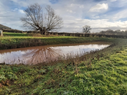
Attenuation pond, Lugg Valley 2024
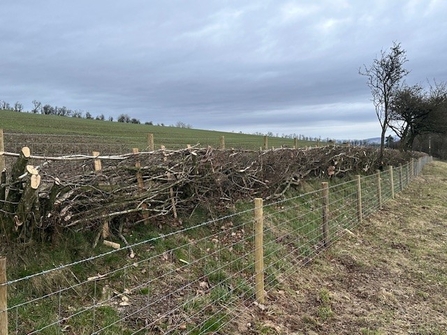
Cross-slope hedgerow, laid and fenced

Example of a leaky dam
Where we're working
We are working with landowners across a number of catchments to implement different natural flood management measures and restoration interventions.
River Wye Catchment
In autumn 2023 we received £462,000 from The National Lottery Community Fund to support farmers and communities to adapt to climate change within the River Wye catchment. Titled 'Wye Adapt to Climate Change', the project is in collaboration with Radnorshire Wildlife Trust and the Wye Valley National Landscape (AONB) Partnership. The project will promote the creation of community climate action networks to support local communities in making positive changes to adapt to the effects of a changing climate. Project staff will also work with landowners to explore nature-based solutions to impacts from climate change such as holding water in the landscape to use for irrigation of agricultural land and prevent flooding of housing and businesses.
Read more about this programme
In 2024 we received funding from the Environment Agency Water Environment Improvement Fund (WEIF) to support practical interventions in the Wellington catchment. These interventions are aimed at improving water quality by reducing sediment and nutrient run-off. This funding supports the Wye Adapt to Climate Change? project.
In autumn 2024 we received £100,000 funding from Welsh Water Environment Fund to help support Natural Flood Management in the upper Yazor brook catchment. Working with landowners we are taking a whole catchment approach and considering the optimal locations for natural flood management interventions in the catchment.
Hereford City - the Yazor Brooks
Local communities are helping to conserve Hereford's Yazor Brooks through wildlife surveys, practical habitat management (including clearing debris, planting trees and building otter holts), hosting events and litter picking.